|
| ||||||
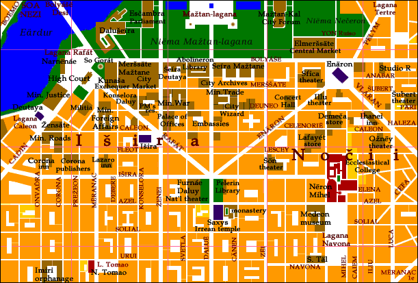
Brown: Points of interest
Red: Eleďe churches
Purple: Pagan or Irrean temples
Yellow: Schools
The 1-cemisa grid is centered on the Observatory at the University. A cemisa is about .75 km.
At the top of the map is the Niëma Mažtan-lagana ('City Plaza Park'), featuring the King's palace (soa Dalušeíra), City Hall (soa Mažtansäte), the Esčambra (Parliament), and the City Forum (Mažtan-Kal).
The Išira quarter, named after the goddess's temple in its center, is the richest quarter of Verduria city. It's also the newest; most of the grid was laid out two centuries ago, during the Eleďe dynasty.
Just south of the park is a band of government buildings-- ministries, official residences, palaces, and embassies. Many nobles, as well as Verduria's new class of rich merchants and manufacturers, have their mansions in the streets just south of this zone. The merely well off live a little further south.
To the east is the Nočii 'Night' district, known for its theaters, nightclubs, restaurants, discos, and stores. The Grand Hippodrome is just off the map to the right.
If this were Sim City, you could see the city infrastructure-- a fairly impressive network of aqueducts, pipes, and fountains bearing fresh water to every block, and underground tunnels carrying away sewage.