|
| ||||||
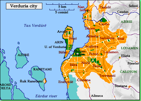
The city was founded around 1200 as Arénica; the name derives from arosd, the Meťaiun word for 'delta'. The original area of settlement corresponds to today's Mažtan-lagana, the campus of government palaces in the center of the city. The fortress of Arcaln was built during the time of the Caďinorian emperor Ervëa, c. 1620. In Caďinorian times, settlement extended to the Scafiora, Nezi, and Biško neighborhoods, as well as along the southern bank of the river.
The city has grown explosively in the last few centuries; it now has close to 600,000 inhabitants. It can be seen that the city walls have been rebuilt further out several times. The innermost existing walls date back to the Arcalnei dynasty (3000s); the Žeuro neighborhood was enclosed in Eleďe times, Istuen and Sarniëma in Abolineron times (3300s).
Times are now safer, and there has been no move to enclose the newer neighborhoods that have grown up outside the walls. These areas are the poorest areas of the city, and most of the kingdom's new factories are found there (except for shipbuilding, of course, which is concentrated in Istuen). The name of Čümána neighborhood is that of the old plague hospital, which was once well outside the city limits, but has been swallowed up by the growth of the city.
Taslelë lies partially up a hill; the refreshing breezes, magnificient view, and distance from the noise and smells of the city have long made it a favorite spot for the nobility-- though they are now joined by the new commercial elite. For city living the rich prefer the Išira quarter.
The meanings of neighborhood and village names may interest some. Meťaiun is the pre-Caďinorian language spoken in the northern Plain, ancestral to modern Kebreni.
| Arin island | |
| Arcaln | Arin fortress |
| Nezi | island |
| Biško | unknown; possibly Meťaiun |
| Inside the walls | |
| Maztan-lagana | city plaza |
| Išira | a goddess; wife of Enäron |
| Nočii | of the Night |
| Žeuro | unknown |
| Istuen | is letuen outside the walls |
| Ažimba | Meťaiun sea goddess (V. Ažirei) |
| Sarniëma | eastern park |
| Scafiora | docks |
| Petrei | after Nëron Petro church |
| Outside the walls | |
| Erabordë | southern shore |
| Čümána | the Plague Hospital |
| Trevmesti | grassy field |
| Lúdamen | olive hill, in Meťaiun |
| Etäš | leafy valley, in Meťaiun |
| Caubo | bee water, in Meťaiun |
| Nan Istuen | north Istuen |
| Taslelë | bay view |
| Nearby villages | |
| Caudan | Caubo town |
| Šelirei | šeli elreë queen's grace |
| Eliata | olive grove |
| Pónefar | manly lord (a given name) |
| Šustana | name of the Fate controlling death |
| Aďmeca | god-daughter |